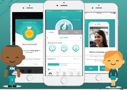
Chicago Department of Transportation

The Chicago Department of Transportation (CDOT) is responsible for public way infrastructure, including planning, design, construction, maintenance and management. Its mission is to keep the city’s surface transportation networks and public way safe for users, environmentally sustainable, in a state of good repair and attractive, so that its diverse residents, businesses and guests all enjoy a variety of quality transportation options, regardless of ability or destination.

The Chicago Department of Transportation (CDOT) Project Coordination Office (PCO) needed to not only increase its investment in street paving projects, but also invest in infrastructure projects to drive efficiency—bringing city departments and utilities together to collaborate on reducing conflicts between construction projects.

Solutions

The CDOT team wanted a new GIS management software that could be used by the City and external utilities to better manage all the projects and meet the operational demands of the CDOT’s Division of Infrastructure Management and Office of Underground Coordination. They worked with SADA Systems a Google Cloud Premiere Partner to design and build an external and intuitive platform to assist in coordination.

The application, dotMaps, is an interactive web mapping service built on Google Maps Platform and Google Cloud Platform, and helps the city manage the work, cut down on conflicts, save taxpayer money, and improve quality of life by reducing unnecessary roadwork and easing traffic congestion. dotMaps, which provides collaborative tools that allow people to create projects and resolve overlapping ones using geolocation, all in real-time, solves a bedeviling problem for city officials and planners: Coordinating public and private construction projects to avoid duplicate work.

$24 million in savings from duplicative work thanks to the web app

More Information

  • UI/UX Design
  • Wireframing
  • Prototyping
  • Updating and Rebranding Style Guide
  • Product Documentation
  • Designed Events Handling and Booking

Google Maps Platform Results

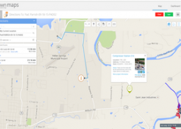
  • All permit, project, and special event data can be viewed in one location with about 30,000 current projects on a live interactive map
  • dotMaps allows someone to see every project within a given radius—a big help when checking for conflicting projects, or gauging the concentration of projects in a single area
  • Helping public and private entities to coordinate work more efficiently, resulting in additional savings in 2014 of more than $24 million

View More

© Copyright - Cayla Torgerson